* ShowMeHills AR mountain peaks
 Show Me Hills is an application which shows the names of hills and mountains superimposed over the camera view (augmented reality!). Contains 325,185 peaks from all over the world! A version just for the UK also exists (for those who prefer a smaller database - see link below).
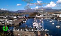
When you look at the landscape using the camera labels giving the mountain names are superimposed directly over the view. The labels can show the distance to the mountain peaks, the bearing, and the height of the mountain. Clicking on a label shows information on the peak with a link to more information (if you have internet access - the rest of the app works fine when you don't!).
Useful for walking and hiking when you want to know the names of the hills and mountains you're looking at!
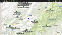
You can switch to a Google Map view which also shows the peaks, plus your location and direction of view.
Show Me Hills is an experimental application that is extremely dependent on your GPS location and handset's compass bearing. If either are inaccurate then the names will appear in the wrong positions. Since the compass on many handsets is very unreliable this can prove frustrating - the application does have the feature to offset the bearing of the compass which can help, and doing the figure of 8 compass calibration can help as well. There are also user options for tweaking the smoothing of compass readings.
While using the camera view you don't need Internet access, but if you switch to the Google map view you'll need it for the maps.
The mountain peak database has been extracted from OpenStreetMap by Mayeul Kauffman - an amazing job, taking the number of peaks from hundreds to almost third of a million!
The app can be moved to the SD card if required, although the database is only about 10Mb, so it's not as large as you might imagine.
UK only version: https://play.google.com/store/apps/details?id=com.showmehills.showmehillsuk
This is a free open source application released under the GPLv3 license, and developers are welcome to contribute at https://github.com/ShowMeHills
If you come across any problems, please report to the email address: nik@showmehills.com
Future plans:
* filtering by prominence
* keep on improving the dataset
* allow photos to be taken with the names
* allow users to report their position to OpenStreetMap
* alternative apps using the same technology (ie a ShowMeTowns type app)
Author: Nik Cain
Version: 0.39
Market link: com.showmehills
Web site: http://www.showmehills.com
Source code:
Code license:
Market downloads: 10,000-50,000
Market rating: 3.6 / 5.0
Category: Top:/Applications/Travel
Added: 2012-07-04
Updated: 2016-04-10
Hits: 1348